Background

Background
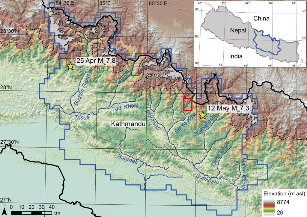
The 2015 Mw 7.8 Gorkha Earthquake
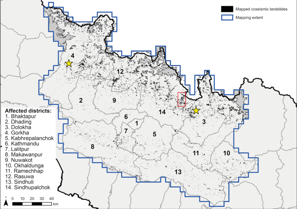
The Gorkha earthquake initiated ~80 km northwest of Kathmandu, with the rupture propagating east ~140 km along the Main Himalayan Thrust (MHT). A series of aftershocks followed, including a Mw 7.3 event on 12 May ~75 km east-northeast of Kathmandu close to the border between Sindhupalchok and Dolakha districts. The intense shaking generated by the earthquake triggered ~25,000 landslides distributed across the full east-west extent of the fault rupture.
The nature of coseismic and post-seismic landsliding
Landslide hazard assessment is difficult in countries with steep topography and a monsoonal climate, but it is made even more challenging given limited scientific and practitioner experience of how earthquake damage affects future landslide hazard and risk. Previous work assessing how landsliding evolves post-earthquake has started to document two key landslide processes. The first is the continued instability and eventual stabilisation of landslides that were triggered by the earthquake. The second is the occurrence of new landslides in the months or years after the earthquake, often in response to intense rainfall, but also as a direct result of coseismic damage to the ground.
However, the timescale over which coseismic landslides remain active and the occurrence of new landslides remains above ‘normal’ levels is poorly constrained. In addition, the interplay and dominance of each of these two forms of landsliding remain poorly documented, and consequently how post-seismic landslides evolve, and the hazard that they pose, is poorly understood.
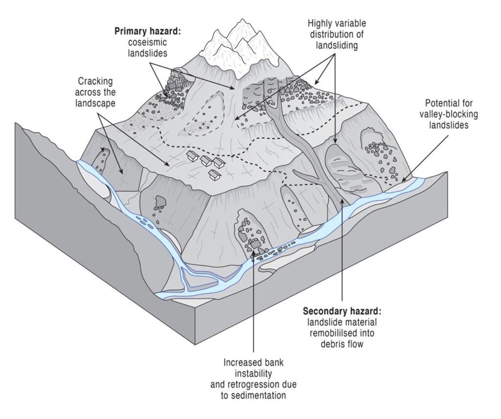
The hazard posed by the reactivation of coseismic landslides can be assessed through the mapping of landslide locations and modelling of potential runout pathways using established flow-routing algorithms. If the evolution of landslides are mapped and analysed through time, this runout modelling approach can then be validated and used to reduce net landslide risk in the years that follow. More challenging still, is the prediction of the likely locations of new landslides in previously (apparently) stable locations. Nevertheless, repeat mapping of landslide evolution in the years after an earthquake allows an assessment of how factors influencing landslide susceptibility change through time, which in turn provides insights into where future landsliding may occur.
Mapping the evolution of landsliding
A core part of our project involved the construction of 14 multi-temporal landslide inventories through manual mapping of landslides visible on medium-resolution (10-30 m) satellite imagery (Landsat 8 and Sentinel-2). Bi-annual inventory mapping covered the period from 2014 to 2020, allowing the impact of the earthquake and six post-earthquake monsoon seasons to be assessed.
The resulting landslide inventories have allowed us to:
- Assess the evolution of landslide hazard and risk in the years immediately after a high magnitude earthquake.
- Model the evolving hazard posed by reactivation and runout from pre-existing landslides.
- Model coseismic and changing post-seismic landslide susceptibility (i.e. the propensity for new future landsliding).
- Generate an atlas of multi-temporal landslide hazard maps to directly assist with risk sensitive land-use planning in Nepal.
- Distil our findings into a series of widely disseminated summary documents, allowing us to communicate key messages and simple rules for landslide risk reduction.
Next Steps – Sajag-Nepal
This DFID-funded project is now complete but the research is being taken forward as part of a new interdisciplinary research project called ‘Sajag-Nepal: planning and preparedness for the mountain hazard and risk chain in Nepal’. The Sajag-Nepal project (2020-2023) is funded by the UK Global Challenges Research Fund (GCRF) and examines how to use local knowledge and new interdisciplinary science to inform better decision making and reduce the impacts of multi-hazards in Nepal. The project is grounded within long-term community-based work with rural residents, and builds on experience of assessing and planning for earthquake and landslide risk with the Government of Nepal, the United Nations, and the wider humanitarian and development community.
More information on the Sajag-Nepal project can be found via the project website (https://www.sajag-nepal.org/) and Twitter page (@SajagNepal).